
1
Xinjiang is the largest province in China with a land area. There are Kunlun Mountains in the south, Altai Mountains in the north and Tianshan in the middle. Between the three mountains, the two largest basins in China are surrounded.
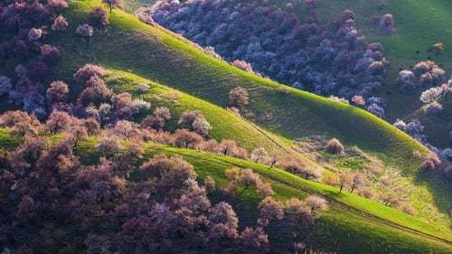

Xinjiang is the largest province in China with a land area. There are Kunlun Mountains in the south, Altai Mountains in the north and Tianshan in the middle. Between the three mountains, the two largest basins in China are surrounded.

Hainan, located at the southernmost tip of the Chinese territory, carries a number of islands in the South China Sea, covering a vast area equivalent to 1/4 of China's land area. The southern Nansha Islands define China's southernmost borders, and the northern Qiongzhou Strait separates Hainan Island from the mainland.

Snow Township, Yabuli Ski Resort, Ice and Snow World... The coldness below minus 20 degrees solidifies different forms of water, not only shaping the extreme north temperament of Heilongjiang, but also making the most leisurely winter the busiest time in the year.

Shaanxi is located in the hinterland of China, because of the Qinling Mountains, China has a south and north, south of the Qinling Mountains is called southern Shaanxi, a scene of Jiangnan, north of the Qinling Mountains is the Guanzhong Plain, known as the 800-mile Qin River, and further north is the heart of the Loess Plateau - northern Shaanxi. This trip will enjoy the very different scenery of the north and south of the Qinling Mountains.

Jiangxi is located in the southeast of China, it is surrounded by mountains on three sides, Mount Lu guards the northern gate, the northern plains are frank, the central hills, the basins are intertwined, thousands of rivers are crisscrossed, most of them converge into Poyang Lake, thus connected with Yangtze River. The journey into Jiangxi starts from Mt.

Our journey begins at the end of the Huangpu River. More than 20 Western-style buildings built on the riverside are the most visible signs of the Bund; the 1,500-meter-long Binjiang section has developed from a muddy shoal to nearly half of China's wealth. The Nanjing Road, which connects the Bund, is brightly lit. It is precisely that it has opened the way for the Chinese to modernize.